 Infill development offers many advantages for people: more housing, jobs and retail options closer to transit, so people don’t have to drive long distances; affordable rents and home prices as more housing is built to match demand; and climate and air quality benefits as less driving and paved open space means less pollution.
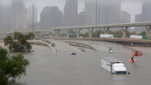
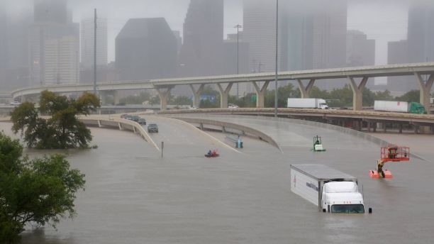
But Hurricane Harvey and the destruction in Houston is now crystallizing another critical benefit of infill: resilience in the face of extreme weather events. As observers have noted, the devastating floods were exacerbated by land use policies that prioritized sprawl over flood control and “green infrastructure” that could have soaked up excess rainwater. More infill development would have saved this open space and avoided building homes that are now essentially destroyed and unlikely to be rebuilt.
Unfortunately, infill development is too often stymied by political barriers — not economic or environmental ones. As Paul Krugman described in an op-ed over the weekend:
In practice, however, policy all too often ends up being captured by interest groups. In sprawling cities, real-estate developers exert outsized influence, and the more these cities sprawl, the more powerful the developers get. In NIMBY cities, soaring prices make affluent homeowners even less willing to let newcomers in.
Krugman compared Houston to San Francisco as two sides of these extremes. Both cities will need infill as a climate resilience strategy: Houston for the flooding we just saw, and San Francisco in the face of sea level rise and more severe droughts (residents in infill developments use less water per capita), among other looming environmental challenges.
So perhaps one bright spot from this tragedy is that infill advocates can now point to Houston as a clear symbol of why infill is also an important adaptation strategy in a world with a rapidly changing climate.
 The unfolding tragedy in Houston from catastrophic rainfall and resulting flooding is probably worsened by two human-caused factors: climate change and bad land use planning. On the climate science, Michael Mann explains how warming waters in the Gulf of Mexico leads to greater rainfall:
There is a simple thermodynamic relationship known as the Clausius-Clapeyron equation that tells us there is a roughly 3% increase in average atmospheric moisture content for each 0.5C of warming. Sea surface temperatures in the area where Harvey intensified were 0.5-1C warmer than current-day average temperatures, which translates to 1-1.5C warmer than “average” temperatures a few decades ago. That means 3-5% more moisture in the atmosphere.
That large amount of moisture creates the potential for much greater rainfalls and greater flooding. The combination of coastal flooding and heavy rainfall is responsible for the devastating flooding that Houston is experiencing.
But at the same time, the city is woefully unprepared for what appears to be a sadly predictable storm. Neena Satija previewed these events in a story last year in the Texas Tribune, in which she blamed poor local land use decisions for the city’s lack of resilience to this type of storm:
Scientists, other experts and federal officials say Houston’s explosive growth is largely to blame. As millions have flocked to the metropolitan area in recent decades, local officials have largely snubbed stricter building regulations, allowing developers to pave over crucial acres of prairie land that once absorbed huge amounts of rainwater. That has led to an excess of floodwater during storms that chokes the city’s vast bayou network, drainage systems and two huge federally owned reservoirs, endangering many nearby homes — including Virginia Hammond’s.
As my colleague Dan Farber notes on Legal Planet, this storm would have caused bad flooding no matter what. But locals throughout the country need to prepare for the “new normal” of climate change with storms and other events like these.
The resiliency planning will cost money and also mean other types of sacrifice. For example, in Houston’s case, large swaths of prairie should probably have been preserved rather than be developed. In other words, infill and smart growth development can be a crucial climate resiliency strategy. As a model here in California, I think of the Yolo Bypass by Sacramento and how that set aside of land for overflow from the Sacramento River saved the city from catastrophic flooding this year.
The events in Houston will hopefully be a wake-up call around the country that we need to preserve and bolster more natural systems to deal with the coming onslaught of extreme weather events, as well as build in smarter locations. And we’ll need forward-thinking people with the will to fund and implement these solutions.
Real estate consulting firm Arup describes the long history of the famously car-centric Houston and a recent vote to approve bus rapid transit:
In 2003, voters approved a major extension of the city’s light-rail system, with one of the planned corridors running through Uptown [an upscale community eight miles from downtown with offices, hotels, one of the nation’s biggest shopping malls, 180,000 residents, and popular restaurants and bars]. Houston’s first light-rail line, the Main Street Red Line, opened in 2004 after having been proposed by the Harris County Metropolitan Transit Authority (METRO) in the 1990s. A northern extension to the Red Line opened in 2013; two additional lines are scheduled to debut this spring. ….
With the future of Uptown’s light-rail line unclear, the district’s leaders discussed other options for reducing traffic congestion. They ultimately chose a model that has proven highly successful around the globe: park-and-ride transit centers connected via bus rapid transit (BRT).
But perhaps the best part of the article is this photo of pro-freeway Houston campaigners in 1958:
“Smash traffic jams?” I’m sure there are lots of other great pro-freeway photos out there that ended up as spectacularly wrong. Feel free to send any you come across, and I can do a future post just on ridiculous pro-freeway photos.


